The Ring of Kerry in brief
The Ring of Kerry is a scenic driving route of 111 miles (179 km) around the Iveragh Peninsula in County Kerry. It starts and finishes in Killarney, follows the N71 to Kenmare, then the N70 around the coast through Sneem, Waterville and Cahersiveen to Killorglin, and returns to Killarney on the N72. In Irish it is Mórchuaird Chiarraí. The roads are open to anyone, with no ticket and no gate.
The question most people ask first is direction. Tour coaches go anticlockwise from Killarney, via Killorglin first, because the roads are too narrow for them to pass each other. If you drive a car, you can go with them or against them. Most drivers who start early do well going clockwise, via Kenmare, and nervous drivers can go with the coaches. The trade-offs are below.
Plan a full day with stops, and two days if you want the Skellig Ring, Valentia Island and an unhurried lunch. Skellig Michael is closed to visitors until 2027. This guide covers direction, timing, the key stops, the Skellig Ring and how to book Skellig boats for 2027, narrow-road driving, tours, and how the Ring compares with Dingle. It works with our Killarney guide, which covers the base town, and the Wild Atlantic Way guide for the coast beyond.
Which direction, and why it matters
The roads on the Ring are narrow in places, and a coach is wide and slow. To avoid coaches meeting head-on on the tightest bends, coach operators send all of their buses the same way: anticlockwise from Killarney, via Killorglin, Cahersiveen, Waterville and Sneem, then Kenmare and back over Moll's Gap. This is an operators' convention, not a law, and sat-nav systems have sent coaches the wrong way before.
For a car driver there are two choices, and each has a catch:
- Clockwise (Killarney, Kenmare, Sneem, Waterville, Cahersiveen, Killorglin). You do not sit behind coaches, which are slow and block views. You will meet them head-on, and on a narrow stretch one of you has to pull in or reverse. Several guides recommend this way. It also leaves the better road for the last leg, when you are tired.
- Anticlockwise (Killarney, Killorglin, Cahersiveen, Waterville, Sneem, Kenmare). You travel with the coaches. You can be stuck behind a slow one, and you may share car parks and viewpoints with a convoy, but you do not have to pass them on narrow roads. Some drivers prefer this for that reason.
Sources disagree on which is easier, so pick the one that suits your nerves. If you are nervous about oncoming coaches, go anticlockwise and leave later in the morning. If you want clear roads and views, go clockwise, leave by about 8:30 a.m., and expect coaches from late morning. Stop at the next wide place whenever you see a coach ahead.
Insider tip
Leave Killarney early whichever way you go. In summer, coaches fill the viewpoints from late morning, and the best light on the coast is often in the late afternoon.
How long to allow
| Version | Driving time | Realistic day |
|---|---|---|
| Main Ring, no stops | About 3.5 hours | Not a real plan |
| Main Ring with stops | About 3.5 hours at the wheel | 7 to 8 hours |
| Ring plus Skellig Ring | About 4.5 hours | 9 to 10 hours |
These are estimates from a 2026 guide. Summer traffic, a farmer moving cattle or roadworks can add time. If you want to enjoy the Ring and not just finish it, split it over two days with a night in Kenmare, Waterville, Portmagee or Valentia Island, or stay near the start in Killarney and drive on a day with good weather. In winter the daylight is short (about 7.5 hours in mid-December, so check timeanddate.com), and you should plan the shorter main loop only.
Key stops, in clockwise order
Torc Waterfall, Ladies View and Moll's Gap
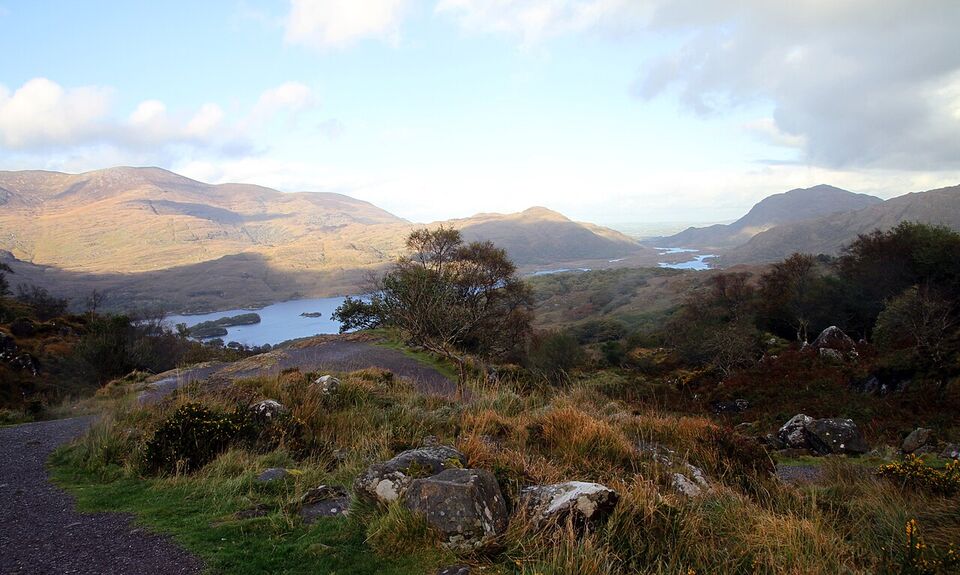
The first leg climbs through the park. Torc Waterfall is a short walk from a small car park. Ladies View is a wide view over the Lakes of Killarney, and Moll's Gap, a pass with a roadside café, looks toward the MacGillycuddy's Reeks. Details are in our Killarney guide.
Kenmare
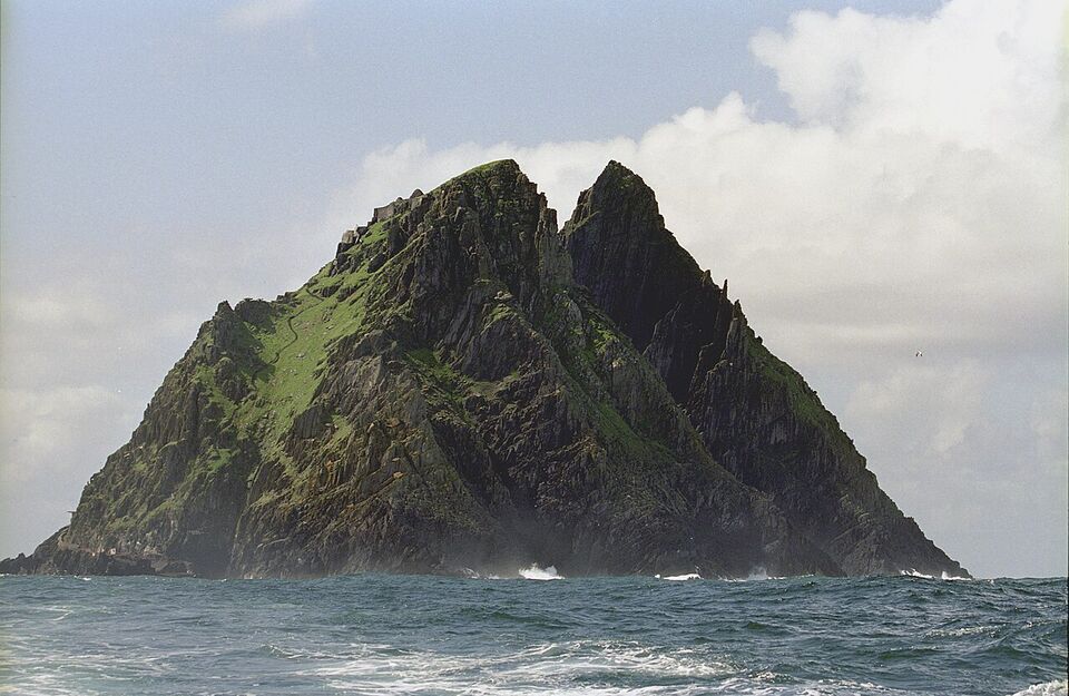
A smaller, quieter town than Killarney, with a stone circle and a good place for coffee, lunch or a night. It is a sensible place to base yourself if you prefer a smaller town.
Sneem
A small village on the south coast of the peninsula, useful for a toilet and a coffee on the way west.
Staigue Stone Fort
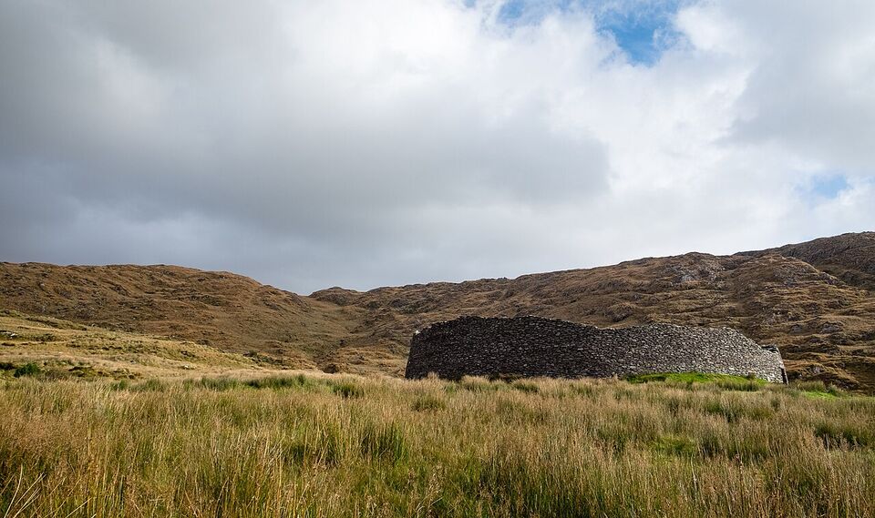
A ringfort built without mortar, with walls up to about 18 ft (5.5 m) high and 13 ft (4 m) thick, thought to date from around AD 300 to 400. The road in is narrow with blind spots. Bring a coin or two for the honesty box.
Caherdaniel and Derrynane
Derrynane Beach has sand and a walk toward Abbey Island and its ruined abbey. Derrynane House, the childhood home of Daniel O'Connell, is a state-run site. Check its winter hours on heritageireland.ie.
Waterville
A small seaside village on a bay, known for golf. Waterville was listed at €425 (about $476) for a summer 2026 green fee (see golf). Coomakista viewpoint, just before it, looks out to Deenish and Scariff islands.
Cahersiveen and Rossbeigh
Cahersiveen has a heritage centre and is the usual access to Valentia Island. Rossbeigh is a 4-mile (7 km) beach by Glenbeigh, a relaxed final stop with plenty of parking.
The Gap of Dunloe, the Black Valley and Carrauntoohil are near the Ring but are not on its route. You can add the Gap as a separate outing from Killarney.
The Skellig Ring and Valentia Island
The Skellig Ring is an unofficial extension of the Ring that leaves the main road near Waterville and loops through Ballinskelligs, the Skelligs telescope viewpoint, St Finian's Bay and the cliffs near Portmagee before rejoining the main route. It adds roughly an hour of driving and several hours of stops, and many people consider it the best part of the peninsula. Roads are narrow, with passing places and sharp bends.
- Kerry Cliffs. Sea cliffs of about 1,000 ft (300 m), reached on foot from a car park on private land. A 2026 guide reports a fee of about €5 (about $6) a person. Check before you go, because private fees change. The walk up is steep for about 10 minutes.
- Valentia Island. About 7 miles (11 km) long, with a permanent population of 658 at the 2022 census. A bridge at Portmagee joins it to the mainland, and a seasonal car ferry from Reenard Point to Knightstown runs from April to October, so in winter use the bridge. Geokaun Mountain and the Fogher Cliffs (180 m, or 600 ft, sea cliffs) have views to the Skellig Islands. A 2026 guide lists €8 (about $9) a car to drive the steep road to the top, and says to take it slowly. Valentia was also the European end of the first commercial transatlantic telegraph cable.
- Portmagee. The small harbor village where many Skellig boats leave, and a base for the area.
Skellig Michael
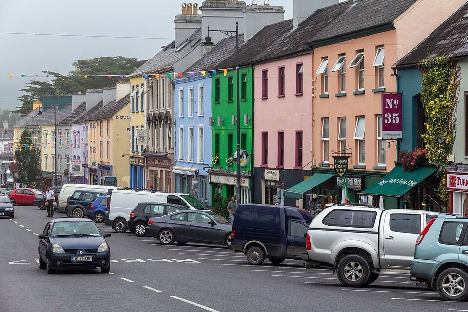
Skellig Michael (Sceilg Mhichíl) is a rock about 7 miles (11.5 km) off the coast, with a monastery of stone beehive huts at the top. It is one of only two UNESCO World Heritage Sites in the Republic of Ireland. The visit involves 618 steep, uneven steps, a climb of over 600 ft (180 m), and no children under 12. The Office of Public Works (OPW) says to allow about 2.5 hours on the island, not counting the boat. Wear sturdy shoes with grip, carry water, and avoid sandals and smooth soles.
Watch out
Skellig Michael is closed. The OPW opened the 2026 season on May 9 and ended it early on September 21 because of weather and sea conditions. Landings are next expected in 2027. As of mid-November 2026 we could not find 2027 dates or boat prices, so do not book Kerry accommodation around a Skellig date until the OPW announces the season.
How to book for 2027
- Watch the OPW page. The 2026 season was listed as mid-May to September, subject to weather and sea conditions. Check the Skellig Michael page on heritageireland.ie for the 2027 announcement. The OPW also asks visitors to watch its safety video before booking, and the contact for queries is opwskellig@opw.ie.
- Book with a licensed boat operator. Site entry is free, but the boats are run by permitted operators who set their own prices. The OPW listed 15 permitted operators for 2026, working from Portmagee, Valentia (Glen Pier), Ballinskelligs and Derrynane. Only a boat on that list can land passengers. We cannot give a price, so ask each operator.
- Ask about cancellations. Landing depends on the swell and the weather. A trip can be cancelled on the day, so ask what happens to your payment, and keep a spare day in your plan.
- Book early and keep the rest flexible. Seats are limited, so book as soon as the operators open sales. Choose accommodation with a cancellation window.
Some operators also run trips around the rocks without landing. We could not confirm which will do so in 2027, so ask when you book.
Narrow-road driving tips
Different from home
The N70 and N71 are "national roads", but they are not highways. Expect one lane each way, stone walls, bends and slow traffic, with speed signs in km/h. A distance that looks short on a map can take twice as long as a US road of the same length.
You drive on the left. Most Ring roads are two lanes, but many stretches are narrow, with stone walls or hedges on both sides, blind bends and no verge. The default speed limit on local roads is 60 km/h (about 37 mph), and regional roads are 80 km/h, but the posted signs rule. Limits are in km/h in the Republic. Nobody expects you to drive at the limit on a bendy section.
- Pull in early. If a coach or lorry is coming, stop at the nearest wide spot or entrance and let it pass. If the road is clear behind you, reversing to a wider place is normal.
- Do not stop on the road. Use car parks and pull-ins for photos. A parked car on a bend forces coaches into the oncoming lane.
- Choose a smaller car. A compact car is much easier on the tight sections than a large SUV. Automatics cost more, so reserve one early if you do not drive a manual at home. Our car rental guide explains insurance and automatics, and the driving guide covers roundabouts and rules.
- Fill up before you need to. Petrol stations are fewer in the remote parts. Top up in Killarney, Kenmare or Cahersiveen.
- Download an offline map. Mobile signal drops out in places, so do not rely on live navigation.
- Watch for walkers, cyclists and sheep. Slow down at bends, and give cyclists room.
Drive or take a tour
| Option | Good for | Trade-offs |
|---|---|---|
| Self-drive | Flexible stops, the Skellig Ring, Valentia, an early start | Narrow roads, coaches, parking at viewpoints, the cost of a car and fuel |
| Guided day tour | Not driving; a driver who knows the roads; the main sights | Fixed stops and times, little time at each; a day tour from Killarney is about 7.5 hours |
| Tour from Cork or Limerick | Doing it without a car if you are staying there | A long day, about 11 hours as listed in 2026 |
We could not confirm current tour prices, which depend on the operator and season, so compare a few and read the cancellation terms. Public transport is limited. Bus Éireann links Killarney and Kenmare, but we found no confirmed bus that circles the whole Ring, so a tour is the practical alternative for visitors without a car. See getting around Ireland for trains and buses to Killarney.
Ring of Kerry or Dingle
The Ring of Kerry and the Dingle Peninsula are close neighbors, and visitors often have time for one. The Ring is the bigger circuit: 111 miles (179 km) with mountains, beaches, small towns, the Skellig Ring and Valentia. It is also the busier one in summer because of the coaches. Dingle is more compact, centers on Dingle town and the Slea Head Drive, and is in the Gaeltacht, where signs may be only in Irish. Our Dingle guide covers it in detail.
If you want a day of varied scenery and the chance of the Skellig coast, choose the Ring. If you prefer a smaller loop with a lively harbor town, choose Dingle. With three nights in Killarney you can do both, one day each, and keep the third for the park. Dingle is about an hour to 90 minutes from Killarney by road (an estimate, not an official time). The regions guide shows how Kerry fits with Cork and the west.
Weather and the winter reality
Kerry is one of the wettest parts of Ireland. Valentia Island, on the peninsula, is the nearest Met Éireann station and records about 203 rain days and 65 in (1,646 mm) a year, with November (about 7.5 in, or 189 mm) and January the wettest months. Daily highs average 64°F (17.8°C) in July and 53°F (11.8°C) in November. Rain and cloud hide the views some days, so keep a spare day if you can.
In winter, expect shorter days, quieter roads and many closures. Seasonal cafés, craft shops and attractions shut, the Valentia car ferry stops after October, and Skellig boats do not run. The main roads stay open. If you drive in November to March, do the main loop only, leave by 9 a.m., fuel up and carry water, a charged phone and a rain jacket. See when to go and what to pack.
Sample plans and mistakes to avoid
- One day
Clockwise from Killarney
Leave by 8:30 a.m. Stop at Torc Waterfall and Ladies View, have coffee at Moll's Gap or Kenmare, then stop at Staigue Fort if the road suits you. Have lunch near Caherdaniel and walk on Derrynane Beach. Take the coast to Waterville and Cahersiveen, finish at Rossbeigh Beach, and be back in Killarney for dinner.
- Two days
With the Skellig Ring
Day one covers the main Ring to Waterville and sleeps in Waterville or Portmagee. On day two, drive the Skellig Ring, see the Kerry Cliffs and Valentia Island, then finish through Cahersiveen and Killorglin. In 2027, plan the Skellig boat for a day with a spare day behind it.
- Starting after 10 a.m. in summer. You will be among the coaches all day.
- Trusting the sat-nav on small roads. Check the route against a map.
- Running low on fuel. Stations are far apart in places.
- Assuming Skellig Michael is open. It is closed until 2027.
- Trying to do everything. Pick a few stops and enjoy the road.
- Stopping on bends for photos. Use pull-ins.
Add it to a route in the trip builder, or ask us to plan the hotels, trains and guides for you.