Overview
Ciudad Perdida ("Lost City," also called Teyuna and Buritaca-200) is an ancient town of stone terraces in the Sierra Nevada de Santa Marta, reached only by a multi-day jungle hike. You cannot go alone: the route runs through indigenous territory and is open only through licensed operators with local guides. The trek is hot, muddy and tiring, and it is one of the most demanding trips in this guide.
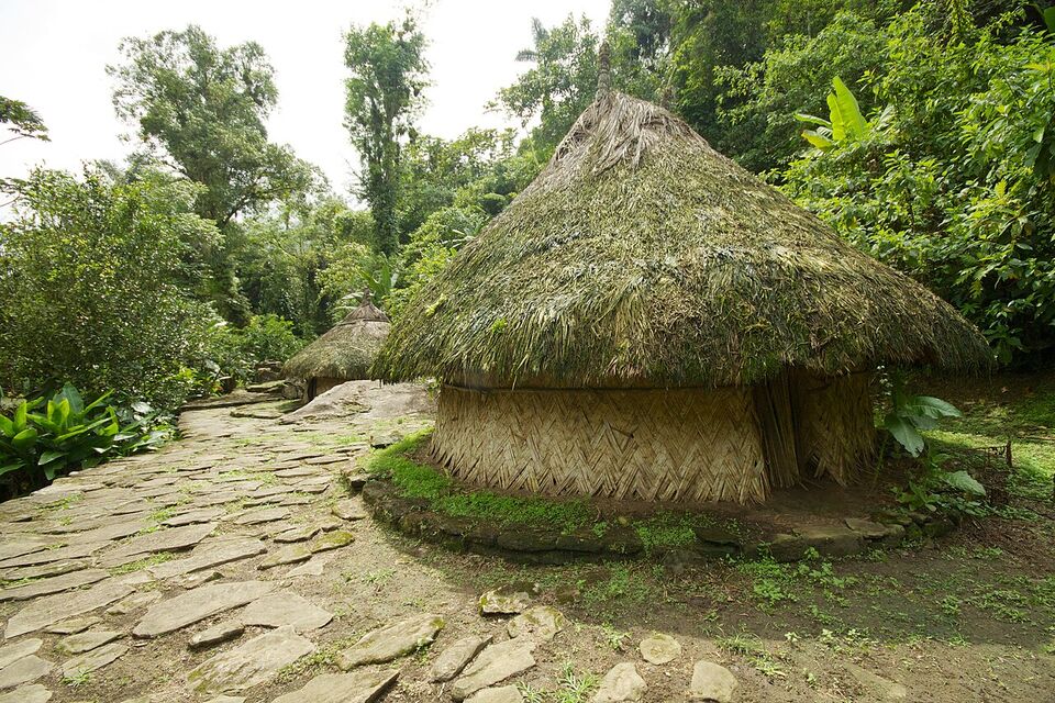
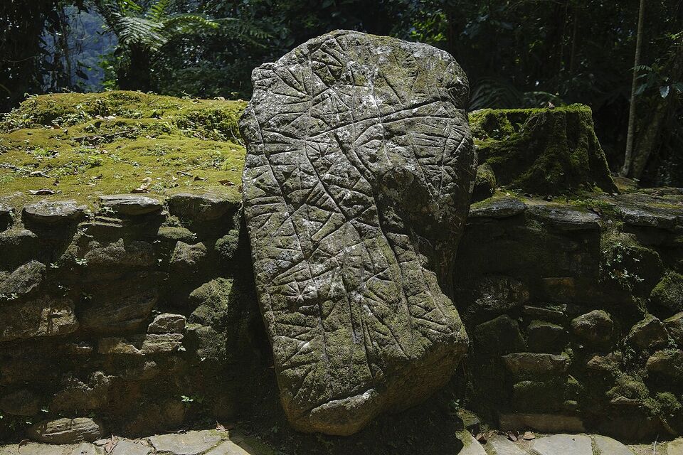
Wikipedia says the city was built about 800 CE by the Tairona, which would make it about 650 years older than Machu Picchu. It has 169 terraces carved into the mountainside, a network of tiled roads and several small circular plazas. You reach the main site by climbing about 1,200 stone steps through dense forest.
The hike usually starts and ends in Santa Marta, so read Santa Marta and Tayrona for the base and the climate. This page covers what the trek is, who runs it, how hard it is, how to choose an operator, what to pack, and the questions to settle before you pay.
Watch out
The most common mistake is booking an unlicensed guide on the street. Cheap offers in Santa Marta or Taganga may not have permission to enter the territory, and may lack insurance, trained guides or a link to the communities. If something goes wrong in the jungle you will have no one to turn to. Book only with a licensed operator, and ask to see its registration.
What Ciudad Perdida is
The site was found in 1972 by a family of treasure looters, who followed a flight of stone steps up the mountain after chasing a bird. Gold figures and ceramics soon began to appear on the black market, which alerted archaeologists. A team from the Colombian Institute of Anthropology reached the site in 1976, and it was reconstructed between 1976 and 1982.
Indigenous Kogui people, who are among the last descendants of the Tairona, say they knew the place before the looters did and call it Teyuna. They see it as the heart of a network of villages their ancestors lived in. Wikipedia estimates that it housed 2,000 to 8,000 people before the Tairona left in the 16th century.
The Sierra Nevada de Santa Marta is the highest coastal mountain range in the tropics. Its two highest peaks reach 18,730 ft (5,710 m), and about 30,000 indigenous people of the Kogui, Arhuaco, Kankuamo and Wiwa groups live in the mountains, according to Wikipedia. Ciudad Perdida lies in the municipality of Santa Marta, but in practice it is part of the communities' lands.
Who runs it and why you cannot go alone
Access is managed by an arrangement between the national parks authority (Parques Nacionales Naturales), the Colombian Institute of Anthropology and History (ICANH) and the Kogui-Malayo-Arhuaco indigenous reservation, Wikipedia says. The communities play an active role in decisions about the territory, and the aim is that tourism does not harm the site or the culture.
In practice this means you book a multi-day package with a licensed tour operator, which provides local guides, simple camps, meals and transport. Reports suggest only a handful of operators are licensed to run the trek. We could not confirm the current list from an official source, and we do not name operators, because licenses and standards change. Ask the parks authority or the Santa Marta tourism office for the current list, and compare it with what the operator tells you.
The trek has not always been open. On September 15, 2003, the ELN guerrilla group kidnapped eight foreign tourists at the site and held them for about three months. Tourist hikes resumed in 2005, and Wikipedia says the Colombian Army patrols the area and that there have been no further kidnappings. That is history, not a promise: read the current US advisory, described below, before you book.
How long and how hard
Operators commonly sell the trek as a guided hike of about 4 to 6 days, but we could not confirm the current options from an official source. The shorter options squeeze the same route into fewer, longer days; the longer ones give you more rest and time at the site. Ask for the daily plan in writing, including hours of walking each day and where you sleep.
| Option | What it means | Who it suits |
|---|---|---|
| Four days | The fastest option: long walking days, little rest | Strong, fit hikers used to heat |
| Five days | A middle choice with a little more rest | Most reasonably fit hikers |
| Six days | The slowest option: shorter days and more time at camps | Anyone wanting a gentler pace or more time with the community |
In plain words
This is a long, steep, hot walk, not a stroll. Each day is several hours on foot, up and down muddy paths, with river crossings by wading or by narrow crossings, and the humidity makes it feel harder. The last push is the climb up about 1,200 stone steps to the site, often early in the morning. You carry your own daypack, and the nights are in simple camps.
If you have knee or ankle problems, a heart or lung condition, or little experience with long hikes, talk to your doctor first. Train with stair climbs and long walks in the boots you will wear, and break the boots in. The heat is a bigger problem than the distance for most people, so arrive acclimatized to humidity if you can.
Heat, mud and river crossings
The Caribbean coast is hot all year. Santa Marta averages highs of about 90°F (32°C) in November and 91-93°F (33-34°C) from January to April, and the Tayrona area has humidity near 87% (Wikipedia, from IDEAM data). In the mountains it can be cooler at night, but mornings and afternoons are sticky.
Plan for wet feet. Rivers can rise quickly after rain upstream, and crossings that were knee-deep in the morning can be deeper by afternoon. Your guides decide when it is safe, and you should follow them. Keep your phone, passport and a change of clothes in dry bags, and pack camp clothes that stay dry.
Insects are part of the trip. Use repellent, wear long sleeves in the evening and sleep under the net your camp provides. The CDC recommends malaria prevention for areas below 5,600 ft (1,700 m) in Colombia, and Santa Marta's foothills are below that line; it also lists a Level 2 yellow fever notice (updated October 16, 2026) and a Level 1 dengue notice (updated November 10, 2026). See health and speak to a travel clinic well before you go.
Best months and the closure question
Santa Marta's dry season runs from December to April, and its wet season from May to November, with September and October the wettest (Wikipedia). The dry season is usually easier on the trail, with less mud and lower rivers. The Sierra holds its own weather, so rain is possible in any month, and the rain months mean slippery steps and higher rivers.
The trek has reportedly closed for about a month a year to let the communities rest the land. One travel blog listed October as the closed month for 2026, and we could not confirm that or the 2027 month from an official source. IDEAM said on November 12, 2026 that a strong El Niño would continue into early 2027, with less rain and higher temperatures expected, so a drier trail is possible but not guaranteed. Always ask the operator which dates are closed before you choose a flight.
Questions to settle before you book
These facts change, and we could not confirm them from an official source in November 2026. Check them with the operators' own sites and with the national parks authority, parquesnacionales.gov.co.
What is the annual closure for 2026-27?
Ask each operator which month the trek is closed in 2027 and what it does if the closure dates change. Ask for a written refund or rebooking policy, and avoid nonrefundable flights until your dates are confirmed.
What is the current price range?
We could not confirm a current price from an official source, so we give no figure. Operators set their own prices, and they may quote in pesos or dollars. A reputable quote usually states what is included: park and community fees, guides, meals, camp beds, transport to the trailhead and insurance. Compare complete quotes, not headline numbers, and be wary of anything far below the others. Cheap often means a corner has been cut.
Has the permit system changed?
The arrangement between the parks authority, ICANH and the indigenous reservation could change, and we have no sign of a change, but we could not confirm it. Ask whether permits or fees changed this year, and whether the operator handles them. If someone tells you that you can pay at the trailhead and go without an operator, treat it as a warning.
How to choose a licensed operator
Use a short checklist. We do not recommend a specific company, because licenses, guides and prices change.
- Ask for the company's national tourism registration number and check it with the authorities.
- Ask whether it is authorized to run the Ciudad Perdida route, and for how long it has done so.
- Ask for the group size cap, the guide's language and the ratio of guides to hikers.
- Get the itinerary, daily walking hours, camps and meals in writing.
- Ask what is included: community and park fees, insurance, transport, meals, water, porters for gear.
- Read the refund and closure terms before you pay, and pay by card or a traceable method.
- Read recent traveler reviews on independent sites, not just the company's own.
Book ahead for the dry months and for holiday weeks. The next holiday Monday is November 16, 2026, and the long weekends of 2027 start with January 11 (see festivals). Contact operators by email well before you travel, and keep the confirmation. If you want to link the trek with the coast, see the plan in Santa Marta and Tayrona and the wider by interest guide.
What a trek day looks like
Operators run similar routines, but ask for yours. Days usually begin early, before the heat, with breakfast at camp and a start on the trail by morning. You walk for several hours, stop for a long lunch in the middle of the day when the sun is highest, and reach the next camp in the afternoon. After a river swim, if conditions allow, you eat dinner early and go to bed soon after dark, because there is little light and the next day starts early again.
Camps are simple: bunks or hammocks under a roof, often with mosquito nets, shared bathrooms and basic showers. Food is usually included and plain: rice, beans, eggs, fruit and local staples. Tell your operator about allergies and dietary needs when you book, not on the trail. Phone signal is poor or absent, so download maps and tell family not to expect messages.
The day you reach the site is the climax. The final climb up about 1,200 steps is slippery after rain, so use the handholds and take it slowly. The guides lead you across the terraces and explain what you are seeing, and you may have a short talk about the Kogui worldview. Photographs may be limited in some places, and your guide will tell you where. Then you walk back the way you came, and the return days feel easier because you know the trail.
Do not expect a cleared archaeological park with ticket booths and rails. It is a restored site in forest, with stone platforms where wooden houses once stood. The journey is much of the point, which is why fitness, patience and a good guide matter more than a camera.
Respect for the Kogui and the land
You walk through indigenous territory, past homes and farms, and the communities have the final say about visitors. Treat the trek as a visit, not an attraction. Greet people politely, and ask your guide before taking photographs of people or sacred places. Stay on the paths and out of areas that are marked as closed. Carry out all trash, and do not buy or accept artifacts.
The Kogui, Arhuaco, Wiwa and Kankuamo peoples have their own languages, customs and beliefs. Guides often explain the cultural context, and it is worth listening. Dress modestly, keep your voice down at the site and follow any ritual requests. See etiquette for wider guidance on behavior.
The same principle applies at nearby Tayrona, where some places are closed to visitors at the wish of indigenous residents. Respect all signs and closures.
Safety in the Sierra Nevada
The US State Department rates Colombia Level 3: Reconsider Travel (as of November 2026), and lists certain areas as Level 4: Do Not Travel. From the secondary reports we read, Magdalena department is not among the areas named, but the list can change, so check travel.state.gov for the current text. It warns of crime, terrorism, civil unrest, kidnapping and natural disasters, and mentions drugging, extortion, kidnapping and armed break-ins.
The advisory's wording is general, so ask your operator about current conditions on the route, including army presence and any recent incidents. Register with the US Embassy through the State Department's traveler program if you want updates. The embassy's 24-hour number for US citizens abroad is +1-202-501-4444 (from the US and Canada: +1-888-407-4747). Colombia's national emergency number is 123. Our safety guide has more.
Tell someone at home your itinerary, buy travel insurance that covers hiking and medical evacuation, and read the policy for exclusions. Leave valuables in your hotel in Santa Marta.
What to pack
- Broken-in hiking boots or trail shoes, plus sandals for river crossings
- Quick-dry shirts and shorts or light trousers, and dry camp clothes
- A light rain jacket or poncho and a dry bag or waterproof liner
- A hat, sunglasses and sunscreen
- Insect repellent (strong), and a head net if you are sensitive to bites
- A headlamp and spare batteries
- A water bottle and purification tablets or filter, if your operator advises it
- Personal medicines, blister care, anti-diarrhea tablets and electrolytes
- A copy of your passport and insurance details, and small cash for drinks and snacks
- A small towel and toiletries in a bag; leave the rest in Santa Marta
Ask your operator for its own packing list and what it provides, such as sleeping sheets and mosquito nets. Keep your bag light: every pound counts in the heat and on the steps. More ideas are on the packing page, and the wider hiking and nature page lists other trips.
Insider tip
Learn a few Spanish phrases and bring a small notebook. Many guides speak some English, but not all, and a few words in Spanish go a long way on the trail and in the camps. See Spanish phrases.
Getting ready and next steps
Start training six to eight weeks ahead with hill walks and stairs while carrying a loaded daypack. See a travel clinic for vaccines and malaria advice at least a month before you go. Book flights only after your operator confirms the dates and the closure calendar. Arrive in Santa Marta a day early to rest and meet your guide.
- Confirm the operator is licensed and the dates are open
- Get the itinerary and inclusions in writing
- Check the State Department advisory the week you travel
- Pack light and waterproof everything
See regions for the other parts of Colombia you can combine with the trek.
Add it to a route in the trip builder, or ask us to plan the hotels, trains and guides for you.